The formula of the real estate market in South Korea's capital region is being fundamentally reshaped. While the absolute standard determining housing prices in the past was the "physical distance (km) to downtown Seoul," the axis is now rapidly shifting to the "actual travel time (min) to key business districts."
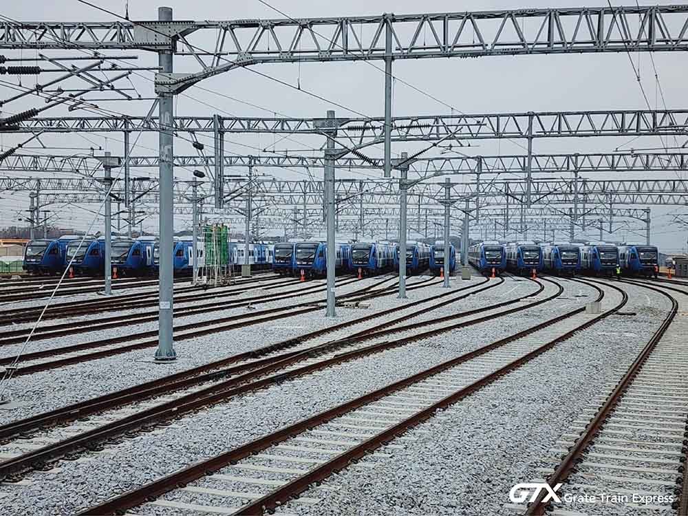
With major metropolitan transportation network projects such as the opening of GTX-A and the Shinansan Line coming into view, key hubs in southern and southwestern Gyeonggi Province are being reorganized into a 'living zone within 20 minutes of downtown Seoul.' This trend goes beyond simple improvements in transportation convenience and leads to structural changes that resolve constraints on urban growth caused by physical distance and redesign the spatial structure of the metropolitan area.
The standard changes from 'kilometers (km)' to 'minutes (min)'

The spatial concept of the Seoul metropolitan area is undergoing an unprecedented transformation. From an era where geographical distance from Seoul determined location value, the actual travel time in minutes has become a more important criterion. At the center of this change is an ultra-high-speed metropolitan transportation network capable of speeds reaching 180 km/h.
The GTX-A line brought about a symbolic change by reducing travel time from Dongtan to Suseo from the previous maximum of 80 minutes to approximately 21 minutes. This went beyond mere time savings and served as an opportunity to break down the psychological barrier of being located on the "outskirts of Gyeonggi-do." By overcoming physical limitations through technology, the area effectively began to be integrated into the same living zone as the Gangnam region.
 In addition, with the GTX-A Paju Unjeong section also enabling travel to Seoul Station in the 20-minute range, the newly opened north-south hubs are forming a single '20-minute economic zone' centered around downtown Seoul. These areas are no longer peripheral but are functioning as key axes of the metropolitan network.
The Shinansan Line, which will change the flow of the southwestern region, follows the same context. Once completed, it is expected that travel from Ansan Hanyang University ERICA Campus Station to Yeouido Station will be possible within approximately 25 minutes by express train. Areas that were previously sidelined due to the burden of commuting are rapidly being incorporated into the everyday living zone of living close to work.
Adding 'transportation acceleration' to the 'industrial foundation'
Recently rapidly emerging cities such as Yongin, Dongtan, and Ansan share a common characteristic: they are not merely bedroom communities, but "ready-made, self-sufficient cities" equipped with solid residential infrastructure and large-scale industrial complexes. The Samsung Semiconductor Belt connecting Suwon, Yongin, and Dongtan, the semiconductor cluster in Cheoin-gu, Yongin, and the Sihwa and Banwol industrial complexes in Ansan are key pillars supporting the Korean economy.
Until now, the physical distance from Seoul has been a bottleneck hindering the inflow of top talent and global capital. Companies struggled to secure talent, and the workforce felt burdened by the prospect of leaving Seoul. The current changes are interpreted as the synergy resulting from the resolution of this bottleneck.
With access to Seoul's core business districts now possible within 20 minutes, a new trend is emerging where Seoul's talent and infrastructure combine with a strong industrial base. It is a structure where the so-called 'industrial foundation' is combined with 'transportation acceleration.'
Now, key talents are moving to high-tech industrial sites in southern Gyeonggi Province using high-speed transportation while maintaining their lifestyles within the Seoul metropolitan area. Capital from Gangnam is also spreading along this transportation network into the business ecosystems of self-sufficient cities, thereby boosting regional value.
The Combination of GTX and Industry: The Gyeongbu Axis Renews Attention
The effects of this transportation revolution are also confirmed in market indicators. The region in the Seoul metropolitan area that showed the steepest growth this year is the Gyeongbu axis line extending from Suji-gu in Yongin through Giheung to Dongtan in Hwaseong.
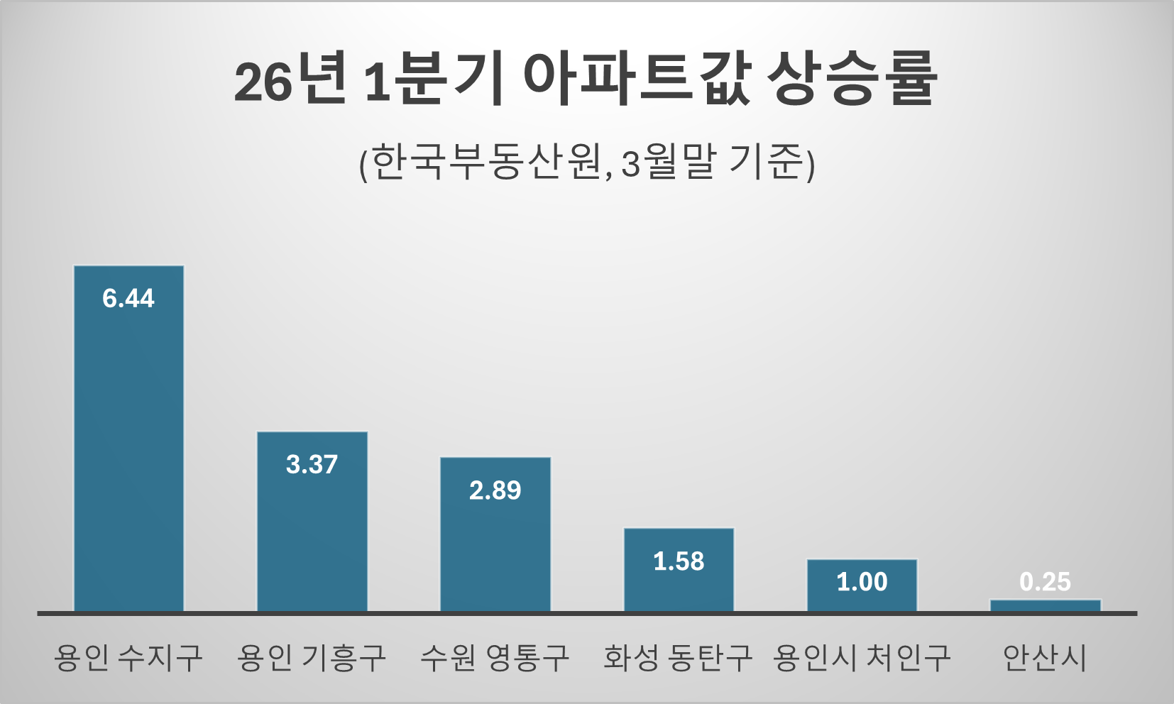
According to data from the Korea Institute of Real Estate, as of March 30, 2026, Suji-gu in Yongin showed a notable trend, rising by 6.441 TP3T from the beginning of the year. This figure significantly exceeds the average for the Seoul metropolitan area and is interpreted as a result of the opening of the GTX being fully reflected in asset values. Giheung-gu (3.371 TP3T), Yeongtong-gu in Suwon (2.891 TP3T), and Dongtan (1.581 TP3T) also led the market by continuing their upward trend.
This upward trend is analyzed as the result of a complex synergy created by the opening of the GTX-A, which made commuting to Gangnam possible in the 21-minute range, coupled with the development of 'Yongin Platform City' centered on Guseong Station and the establishment of the National Semiconductor Industrial Complex in Cheoin-gu. The Gyeongbu Corridor in southern Gyeonggi is now being reorganized beyond a mere residential hinterland into a core economic axis of the metropolitan area that generates added value on its own.
A transportation revolution spreading across the metropolitan area
This success formula is spreading throughout the metropolitan area. In particular, expectations are high for the Shinansan Line, a key axis of the southwestern region. Ansan is set to establish a transportation network connecting Yeouido and Hanyang University’s ERICA campus in approximately 25 minutes, and following its opening, it is expected to leap forward as a "manufacturing and research hub" combining manufacturing industries with financial capital.
In the southeastern region, Wirye New Town is drawing attention. With the opening of the Wirye Tram and the full-scale implementation of the Wirye-Sinsa Line project, Wirye is expected to establish itself as a leading new town with excellent accessibility to Gangnam. As the final piece of the puzzle—the transportation network—is completed, the city is evolving from a residential-focused urban center into a complex city equipped with business support functions.
The map of wealth being reshaped by 'time'

The spatial paradigm of the metropolitan area has already shifted. Maps are no longer being drawn based on administrative boundaries, but on the practical criterion of 'travel time.'
Initially, there were concerns that the expansion of the metropolitan transportation network would intensify the concentration of resources in Seoul, known as the "straw effect." However, the market is currently moving in a different direction. This is because a "two-way circulation structure," in which talent and capital from Seoul spread to self-sufficient cities in southern and southwestern Gyeonggi Province, is becoming increasingly distinct.
This means that transportation networks have begun to function not as channels for absorbing resources, but as 'economic arteries' that circulate resources between cities.
Only companies that understand the nature of change can secure the initiative in the newly reshaped business landscape. Now is a critical moment to realign corporate location strategies and asset portfolios based on the criterion of 'time'.